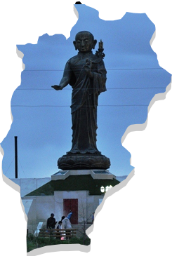
The central geographical point of Mongolia is at the front side of Ongon Mountain, Burd soum, contained within the Uvurkhangai Province. The province is predominantly steppe in the central region, with the Branch Mountains of the Altai range and sandy steppe in the southern part, and with the branch mountains of the Khangai rabge in the northern part.
Since the province is divided into three distinct zones, it is rich with natural resources. There are plenty of high mountains and hills with elevations between 2,000-3,590m such as Khyatruun, Bituut of Khangai range, Bagabogd and Myangan Yamaat of Mongol-Altai range. Other highlights include the 24 meter high waterfall of Orkhon river named “Ulaan Tsutgalan”, the unique Khuisiin Naiman lakes and Tamchiin Yol Cliffs at an elevation of 2,500m above sea level. This as well as impressive steppes such as Arvaikheer, Shagj, Doloodoi, Khongor, Guchingiin Tal and Orkhon Valley lie in this province.
The northern part of the province contains the Branch Mountains of the Khangai range whereas the southern part is predominantly the steppe. The Bagabogd and Artsbogd mountains are found in this region. The central and northeastern parts of this province have an Early Mesozoic Era sandy stone and hornstones, while the southwestern part has Cretaceous Period moraines.
Rivers like the Orkhon, Ongi, Taats and Ar Agui flow through the Uvurkhangai Province. Large lakes like Ulaan Tsutgalan, Naiman Nuur and Taatsyn Tsagaan and numerous springs like Khujirtyn, Mogoit, Khyatruun, Khuremtiin, Taats, Mustiin, Khuren Khad, Khorkhoi Turuu and Takhiin, all belong to this province.
According to geological research, 4 gold deposits and 10 further detections have been established in this province, as well as 9 precious metal, 4 nonferrous metal, 2 iron ore, 4 mineral paint, one salt deposit and 12 construction material resource deposits.
