Zavkhan Province is located at the western part of Mongolia and borders with the Khovd and Uvs provinces in the west, the Tuva Republic of the Russian Federation in the north, the Khuvsgul and Arkhangai provinces in the east, and Bayankhongor and Govi-Altai provinces in the south respectively. It is one of five provinces that were established in 1923. Total territory is 82,500 km2 and the distance of its capital city Uliastai from Ulaanbaatar is 1,104 km.
The capital is surrounded by many high mountains including the Otgontenger – the highest peak of Khangai Mountain range at 4,031m and its branch mountains such as Tarvagatai (3,227m), Khurimt, Tudevtei, Gurvan Khaltar, Gyalgar and Bulnai mountain (2,619m) in the east and by the branch mountains of the Tagnyn Tange in the north. The western part of the province contains steppes with river valleys, hills and hillocks. There is a wide valley containing the Ider, Zavkhan, Tes, Bogdyn and Khungyn rivers among the mountains.
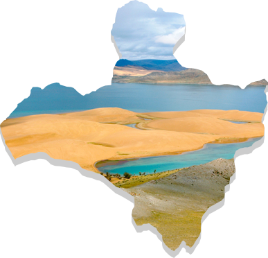
In the western and south western parts are contained the Borkhyryn sand dunes that last for 100 to 200 kms. The area is rich in iron ore, tin, gold, copper, diamond, molybdenum, precious stones, alabaster, phosphates, ore, construction material resources and different chemical elements. Wild berries are abundant in the forests. The province has an extreme continental climate. The average temperature in January drops to -20 to 300C and in July reaches 13 to 220C. The lowest ever recorded temperature was ‑530C which was also the lowest for the whole country (occurred in Tosontsengel). The average annual precipitation is 400 mm in the high mountain areas, 80-100 mm in the western parts and 200-260mm throughout the rest of the province.
The province has landscape of Gobi desert and Khangai Mountain. It has over 40 natural attractions with 189 rivers, 91 lakes and a variety of hot and cold springs. The province intends to better develop tourism opportunities and prospects.